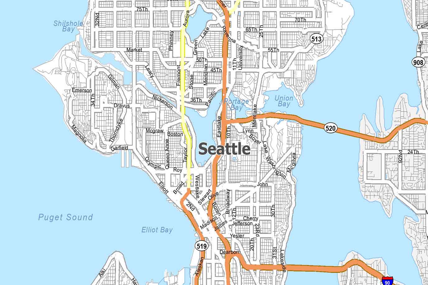
Seattle isn’t the kind of city you just pass through. It’s a place that draws you in slowly—through the aroma of fresh-roasted coffee that seems to linger around every corner, the sea breeze that greets you as you walk along the waterfront, or the hum of creativity that vibrates from indie bookstores, public art, and hidden speakeasies. But for a first-time visitor, it can also be… a little overwhelming.
When I first arrived in Seattle, I remember feeling excited but disoriented. The streets downtown seemed to slope unpredictably. Neighborhoods I had read about—Ballard, Capitol Hill, Fremont—felt like distant names on a map I couldn’t yet visualize. That’s when I realized something crucial: a good city map, one that you can access offline, one that highlights both popular sites and local gems, can change your entire experience.
This article is a practical, heartfelt guide to finding, downloading, and using the latest Seattle city map, especially tailored for first-time visitors. But more than just navigation, this is about how to experience the city with ease and delight.
Why You Absolutely Need a City Map in Seattle
Seattle’s geography is unique—surrounded by water on both sides (Lake Washington to the east, Puget Sound to the west), the city is built on rolling hills with a layout that isn’t always intuitive. Some areas are hyper walkable (like Belltown and Capitol Hill), while others, like West Seattle or Green Lake, may require a car or transit.
Even with Google Maps, I’ve found that a detailed, curated city map gives you context that algorithms don’t: neighborhoods with character, mural alleys you might otherwise miss, ferry terminals, and pedestrian paths. When you hold a city map—or download a well-designed digital version—you orient yourself in a way that helps you feel present, not just directed.
Where to Download the Latest Seattle City Map (Free!)
You don’t need to buy a paper map from a tourist kiosk anymore. Seattle’s tourism board and several travel tech companies offer updated, downloadable maps that are designed for offline use. Here are the most reliable:
1. Visit Seattle Official Map
Available at VisitSeattle.org, this map is comprehensive and user-friendly. It highlights hotels, attractions, neighborhoods, public transportation lines, and walking tours. The PDF version is printable, but you can also keep it saved on your phone.
When I used this map, I loved that it included brief descriptions for each neighborhood. Reading about Fremont’s quirky art scene while standing next to the Fremont Troll was a small delight.
2. Maps.me (Offline Map App)
This has become my go-to while traveling. Download the “Seattle” map pack before your trip, and you’ll have detailed, GPS-enabled access without needing data. It includes hiking trails, ferry docks, public restrooms, ATMs—basically everything a traveler might need. I used it extensively when wandering Discovery Park, far from downtown cell towers.
3. Google Maps Offline Mode
While not a “city map” in the traditional sense, this is still a must. Before you travel, go into Google Maps > Your Profile > Offline Maps > “Select Your Own Map.” Download Seattle and surrounding areas. It works seamlessly for navigation without signal, though some POI (points of interest) details may be limited.
How I Use My Map: Day-by-Day Travel Tips
Your map shouldn’t just be a backup—it should be part of your planning and discovery process. Here’s how I integrated it into my itinerary:
Day 1: Orientation & Downtown Discovery
I arrived at Seattle-Tacoma International Airport (SEA) mid-morning and took the Link light rail into the city. With my map open, I tracked where I was and which stops led to what. This helped me confidently get off at Westlake Station, the heart of downtown.
From there, I walked toward Pike Place Market, my map showing me side streets with fewer crowds. A small alley caught my eye—Post Alley—and I stumbled upon the famous (and kind of disgusting) Gum Wall. Without the map highlighting it, I might’ve walked right past.
Tips for Day 1 Mapping:
- Highlight your hotel in advance.
- Pin restrooms (there are several near Pike Place and Seattle Aquarium).
- Map out restaurants. I booked dinner at The Pink Door, a spot tucked away behind a non-marked entrance. Use OpenTable or Yelp to check reviews and reserve in advance.
Best Seattle Neighborhoods to Explore with a Map
Let’s dive into some of Seattle’s most captivating neighborhoods and how a city map will help you navigate each one like a local.
Capitol Hill: Culture, Coffee, and LGBTQ+ Pride
Capitol Hill is layered. You’ll find indie bookstores like Elliott Bay Book Company, rooftop bars, rainbow-painted crosswalks, and quiet green corners like Volunteer Park. Without a map, it’s easy to miss half the magic. One morning, I wandered from my hotel (I stayed at Hotel Sorrento nearby) into a leafy residential street, only to end up at the Seattle Asian Art Museum—a place I hadn’t planned to visit but was so grateful I did.
Tip: Capitol Hill is very walkable but hilly. Use your map to avoid overly steep climbs if you’re planning a relaxed day.
Ballard: Nordic Heritage and Water Views
Ballard is off the usual tourist path but worth every second. With my downloaded map, I charted a bus route that took me from downtown to the Ballard Locks, where boats pass between fresh and saltwater, and salmon jump up the fish ladder.
Nearby is the National Nordic Museum, great food at The Walrus and the Carpenter, and trendy boutiques. Use TripAdvisor or Resy to secure food spots ahead—popular places book fast here.
Fremont: The Center of the Universe
Yes, that’s literally what Fremont calls itself. It’s full of quirky sculptures, including the Fremont Troll under the Aurora Bridge. Using a city map helped me navigate its winding streets and discover the Sunday Market, a flea market bursting with handmade jewelry, art, and vintage finds.
Fremont also connects to the Burke-Gilman Trail, a walking and biking path stretching through multiple neighborhoods. This isn’t on Google Maps by default—so having a specialty map app like Maps.me or AllTrails helped me follow the route without missing scenic turnoffs.
Using the Map for Public Transit
– Light Rail
– Seattle Streetcar
– Water Taxis and Ferries
– How to navigate ORCA card purchases
Hidden Gems You’ll Find Only with a Good Map
– Pocket parks
– Rooftop viewpoints
– Secret coffee windows
– Murals and street art corridors
When to Use Paper vs. Digital Maps
– Battery anxiety is real
– Print one as backup for day hikes or remote locations
– Offline apps for neighborhoods with spotty service
Downloadable Map Resources for Seattle Visitors
– Best printable PDF maps
– Where to pick up free physical maps in town
– QR codes at visitor centers
Where to Stay: Mapping Your Hotel to Maximize Your Experience
– Recommended hotels by neighborhood
– Using Booking.com, Expedia, and Airbnb filters to match your travel style
– Why location matters more than amenities in Seattle
Plan Around Food: Map Your Culinary Journey
– Must-eats: seafood, pho, Korean BBQ, teriyaki
– Use Yelp, Google Reviews, Resy to book tables in advance
– Create a food map with personal pins
Booking Flights, Attractions, and More with the Right Platforms
– For flights: Google Flights, Hopper, Skyscanner
– For hotels: Booking.com, Hotels.com, Expedia, Priceline
– For activities and city tours: GetYourGuide, Viator, Tiqets
– Combine these with your city map for a seamless travel plan
Navigating Seattle Public Transit with Your Map
Seattle is a city best explored on foot, bike, and transit. But navigating public transportation for the first time can be intimidating—especially in a city with multiple systems (bus, light rail, ferries). That’s where a well-labeled map becomes your best friend.
Link Light Rail
This is your lifeline between the airport and downtown. Stops include:
- SEA (Airport)
- Columbia City (cool cafés)
- Capitol Hill
- Westlake Center (core downtown)
- University of Washington
I downloaded a transit map overlay from SoundTransit.org and saved it to my phone. It made route planning seamless. Fares are affordable—between \$2.25–\$3.50 depending on distance.
Streetcar & Monorail
The First Hill Streetcar connects Capitol Hill with the International District—great for food adventures. And the Monorail? A short but iconic ride from downtown to Seattle Center. Use it when visiting the Space Needle or Chihuly Garden & Glass.
Buses & Water Taxis
King County Metro buses crisscross the city, and you can pay by tapping your ORCA card (Seattle’s all-in-one fare card). You’ll also find Water Taxis to West Seattle—a scenic shortcut that turns your commute into a harbor cruise.
Tip: Use the Transit app, which syncs with your city map and gives real-time transit updates. It’s a game-changer during busy hours.
Hidden Gems You’ll Discover Only With a Good Map
The best travel moments often come unplanned. But having a thoughtfully marked map makes “serendipity” more likely. Here are some of the spots I found because my map nudged me a little off-course:
1. Streissguth Gardens
Tucked beside the Blaine Street Steps on Capitol Hill, this secret garden is a lush haven—dense greenery, winding paths, no tourists in sight.
2. Smith Tower Observatory
Everyone flocks to the Space Needle, but Smith Tower’s 35th-floor observatory offers historic charm and sweeping views—for half the price. I only discovered it thanks to a local’s recommendation and a pin on my map.
3. Waterfall Garden Park
Right in the middle of Pioneer Square is a waterfall oasis. Yes, a real waterfall! Surrounded by brick buildings, this is a calm hideaway where I stopped for coffee and reflection.
4. Melrose Market
An urban market tucked just off Pike Street, with artisanal food, wine, flowers, and handmade gifts. Great for a quiet brunch away from the crowds.
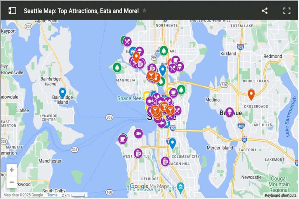
Tip: Keep a digital map with your own pins for favorite discoveries. I color-coded mine: food (red), views (blue), and hidden gems (gold).
Should You Use a Paper Map or Digital One?
I’m a fan of both. Here’s why:
Digital Maps (Google Maps, Maps.me, Transit App)
- Easy to update and customize
- GPS-enabled: helps you track your location even offline
- Great for marking pins and directions
Paper Maps
- Don’t rely on batteries or signal
- Offer a full, zoomed-out view of the city
- Easier to write on, highlight routes, and plan out multi-stop days
Best Paper Maps Available in Seattle:
- Visit Seattle Visitor Centers (locations at Pike Place and SEA Airport)
- Seattle Central Library has a map rack with walking guides
- Hotels and concierge desks often provide local guides with restaurant recommendations
I personally print a high-res map before my trip and fold it into my backpack. It’s saved me more than once in dead zones and during rainy days when my phone was tucked away.
Booking the Right Hotel – Why Your Map Location Matters
Where you stay in Seattle dramatically shapes your experience. Using a city map to scout your hotel location in advance is smart—not just for proximity to attractions, but for vibe, walkability, and noise level.
Recommended Areas for First-Time Visitors:
- Downtown (Westlake, Pike Place): Central and walkable
- Belltown: Trendy restaurants, near waterfront
- Capitol Hill: Culture, nightlife, LGBTQ+-friendly
- South Lake Union: Quiet, business district with views
Platforms for Hotel Deals in the U.S.:
- Booking.com: Good filters by neighborhood
- Expedia: Combine hotel + flight for savings
- Hotels.com: Loyalty program with free nights
- Priceline: Best for last-minute bookings
Map Tip: Search hotels by map view. This is my go-to method—especially when trying to balance price and location. Always zoom in to see where exactly you’ll be sleeping.
Planning Around Food – Map Out a Culinary Route
Seattle is a food lover’s dream. From salmon-topped bagels to dumplings, Ethiopian platters to vegan bakeries, there’s no shortage of flavor. But with so many choices, you need a map to organize your journey.
My Mapped Food Strategy:
- Breakfast Zone: Local cafés near your hotel (try Storyville Coffee near Pike Place)
- Midday Market: Use your map to trace a food crawl—Beecher’s Cheese, Piroshky Piroshky, The Crumpet Shop
- Dinner: Reserve in advance via OpenTable or Resy
- Late Night: Use Yelp to locate food trucks or 24-hour diners
Tip: Make a Google Map layer with restaurant pins. I even added notes for what to order. For example, “Taylor Shellfish: try the Shigoku oysters.”

Getting Around, Booking Flights & Attractions with Ease
Beyond the map, your trip runs smoother with the right platforms:
Flight Booking:
- Google Flights: My favorite for tracking trends
- Hopper: Predicts price drops
- Skyscanner: Best for flexible dates
Activities & Tours:
- GetYourGuide: Walking tours, Pike Place tastings
- Viator: Kayak rentals, Mt. Rainier day trips
- Tiqets: Museums, observatories, combo tickets
Travel Insurance Tip: Always get coverage, especially in rainy Seattle where flight delays are common. Try Allianz Travel or World Nomads.
Let the Map Be Your Compass, Not Your Script
Seattle rewards those who explore with curiosity and intention. A city map—especially one that’s downloaded, marked, and brought to life—gives you more than directions. It gives you a framework for spontaneity. The chance to look up from your screen and discover a tiny bookstore tucked behind a mural. A quiet bench at Olympic Sculpture Park where the sunset feels private. A ferry to Bainbridge Island you didn’t plan to take… but did, because your map showed you it was just around the corner.
You don’t need to see everything. But with a great map in hand, you’ll feel connected to wherever you do go.
Final Tips:
- Always keep a charger or battery bank for your phone
- Download offline maps in advance
- Print a backup paper map for longer hikes or island day trips
- Use map view on booking platforms to avoid surprises
- Drop pins on discoveries so you can return—or recommend them to friends
So go ahead. Download your Seattle city map, pack your walking shoes, and let your own adventure unfold—one beautiful turn at a time.
